
(Reading the disclaimer before use is suggested)
(E)F5 Cases: 4% | (E)F4 Cases: 22% | (E)F3 Cases: 26%
Welcome!
This page was originally created for the CMU Student Chapter of the AMS website and has been recreated here. This page acts as a library of model reanalysis vertical profiles (soundings) that represent near-storm environments of notable Michigan tornado and significant hail events from 1940-present using RAP/RUC (UCAR) & ERA-5 (ECMWF) reanalysis data. This archive is meant to act as a reference and to aid CMU student forecasters in pattern recognition of tornadic environments in Michigan.
Total cases in archive: 63 | Dates: 1943-2024
TORNADO CASES BY DECADE:
– The 1940s –
May 31, 1943 | Coopersville F2
May 31st, 1943
Coopersville, MI F2
EVENT LOCATION: Ottawa County | Coopersville
EVENT DATE: May 31st, 1943 – 10:30 PM ET
NUMBER OF TORNADOES: 1
MAX TORNADO RATING(S): F2
MAX PATH LENGTH: 8.3 miles / 13.3 km
MAX WIDTH: 300 yd
MAX WIND: UND
MODEL DATA: MODEL: ECMWF ERA-5 (PRELIM BACK EXTENSION) F00 – RUN: 06/01/43/02 UTC – VAILD: 06/01/43/02 UTC – LOCATION: Allendale, Mich
Read more about this event:

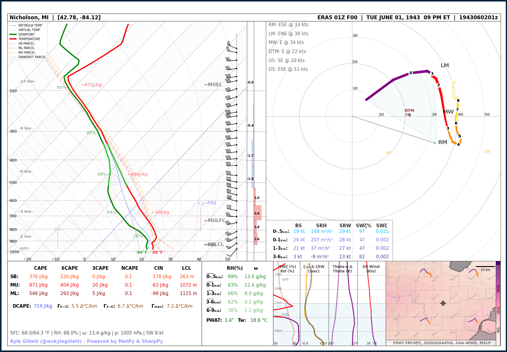
Jun 1, 1943 | Perry/Morrice MI F4
June 1st, 1943
Perry-Morrice, MI F4
EVENT LOCATION: Ingham and Shiawassee County | Perry, Morrice, Bancroft, Durand
EVENT DATE: June 1th, 1943 – 9:00 PM ET
NUMBER OF TORNADOES: 3
MAX TORNADO RATING(S): F4
MAX PATH LENGTH: 17.6 miles / 28.3 km
MAX WIDTH: 400 yd
MAX WIND: UND
MODEL DATA: MODEL: ECMWF ERA-5 (PRELIM BACK EXTENSION) F00 – RUN: 06/02/43/01 UTC – VAILD: 06/02/43/01 UTC – LOCATION: Nicholson, Mich
Read more about this event:
Jun 17, 1946 | Metro Detroit – Windsor F4
June 17, 1946
Metro Detroit – Windsor F4
EVENT LOCATION: Wayne County | Metro Detroit to Windsor, ON
EVENT DATE: June 17th, 1946 – 6:55 PM ET
NUMBER OF TORNADOES: 2
MAX TORNADO RATING(S): F4
MAX PATH LENGTH: 17.4 miles / 23.1 km
MAX WIDTH: 200 yd
MAX WIND: UND
MODEL DATA: MODEL: ECMWF ERA-5 (PRELIM BACK EXTENSION) F00 – RUN: 06/17/46/22 UTC – VAILD: 06/17/46/22 UTC – LOCATION: Lincoln Park, Mich
Read more about this event:

Sep 24, 1946 | Escanaba F2
September 24, 1946
Escanaba F2
EVENT LOCATION: Delta County | Escanaba
EVENT DATE: September 24th, 1946 – 18:45 PM ET
NUMBER OF TORNADOES: 1
MAX TORNADO RATING(S): F2
MAX PATH LENGTH: 3 miles / 4.8 km
MAX WIDTH: 200 yd
MAX WIND: UND
MODEL DATA: MODEL: ECMWF ERA-5 (PRELIM BACK EXTENSION) F00 – RUN: 09/24/46/18 UTC – VAILD: 09/24/46/18 UTC – LOCATION: Escanaba, Mich
Read more about this event:

– The 1950s –
Jun 8, 1953 | The Great Flint-Beecher F5 (10th Deadliest Tornado in US history)
June 8, 1953
The Great Flint-Beecher F5 (10th Deadliest Tornado in US history)
EVENT LOCATION: Genesee and Lapeer County | Mount Morris to North Flint to Columbiaville
EVENT DATE: June 8th, 1953 – 9:30 PM ET
NUMBER OF TORNADOES: 7
MAX TORNADO RATING(S): F5
MAX PATH LENGTH: 18.9 miles / 30.4 km
MAX WIDTH: 833 yd
MAX WIND: UND
MODEL DATA: MODEL: ECMWF ERA-5 (PRELIM BACK EXTENSION) F00 – RUN: 06/09/53/01 UTC – VAILD: 06/09/53/01 UTC – LOCATION: Flint, Mich
Read more about this event:

Jun 8, 1953 | Lapeer and St. Clair F4
June 8, 1953
Lapeer and St. Clair F4
EVENT LOCATION: Lapeer & St. Clair County | Kings Mill – Yale – North Lakeport
EVENT DATE: June 8th, 1953 – 11:30 PM ET
NUMBER OF TORNADOES: 7
MAX TORNADO RATING(S): F4
MAX PATH LENGTH: 33.8 miles / 54.3 km
MAX WIDTH: 830 yd
MAX WIND: UND
MODEL DATA: MODEL: ECMWF ERA-5 (PRELIM BACK EXTENSION) F00 – RUN: 06/09/53/03 UTC – VAILD: 06/09/53/03 UTC – LOCATION: Goodland, Mich (6 miles SE Kings Mill, Mich)
Read more about this event:

Apr 3, 1956 | Grand Rapids Long Track F5 (Michigan’s Most Recent (E)F5)
April 3, 1956
Grand Rapids Long Track F5 (Michigan’s Most Recent (E)F5)
EVENT LOCATION: Ottawa, Kent, Montcalm Counties | Vriesland to Grand Rapids to Trufant
EVENT DATE: April 3rd, 1956 – 6:40 PM ET
NUMBER OF TORNADOES: 4
MAX TORNADO RATING(S): F5
MAX PATH LENGTH: 58.8 miles / 94.6 km
MAX WIDTH: 400 yd
MAX WIND: UND
MODEL DATA: MODEL: ECMWF ERA-5 (PRELIM BACK EXTENSION) F00 – RUN: 04/03/56/22 UTC – VAILD: 04/03/56/22 UTC – LOCATION: Grand Rapids, Mich
Read more about this event:
NWS GRR: https://www.weather.gov/grr/1956TornadoOutbreakVrieslandTrufant

Apr 3, 1956 | Lake Michigan to Grand Traverse Bay Long Track F4
April 3, 1956
Lake Michigan to Grand Traverse Bay Long Track F4
EVENT LOCATION: Manistee, Benzie, Grand Traverse, Leelanau Counties | Onekama to Bingham
EVENT DATE: April 3rd, 1956 – 7:35 PM ET
NUMBER OF TORNADOES: 4
MAX TORNADO RATING(S): F4
MAX PATH LENGTH: 50.3 miles / 80.9 km
MAX WIDTH: 400 yd
MAX WIND: UND
MODEL DATA: MODEL: ECMWF ERA-5 (PRELIM BACK EXTENSION) F00 – RUN: 04/03/56/23 UTC – VAILD: 04/03/56/23 UTC – LOCATION: Cadillac, Mich (40 miles E Onekama, Mich)
Read more about this event:
NWS GRR: https://www.weather.gov/grr/1956TornadoOutbreakVrieslandTrufant
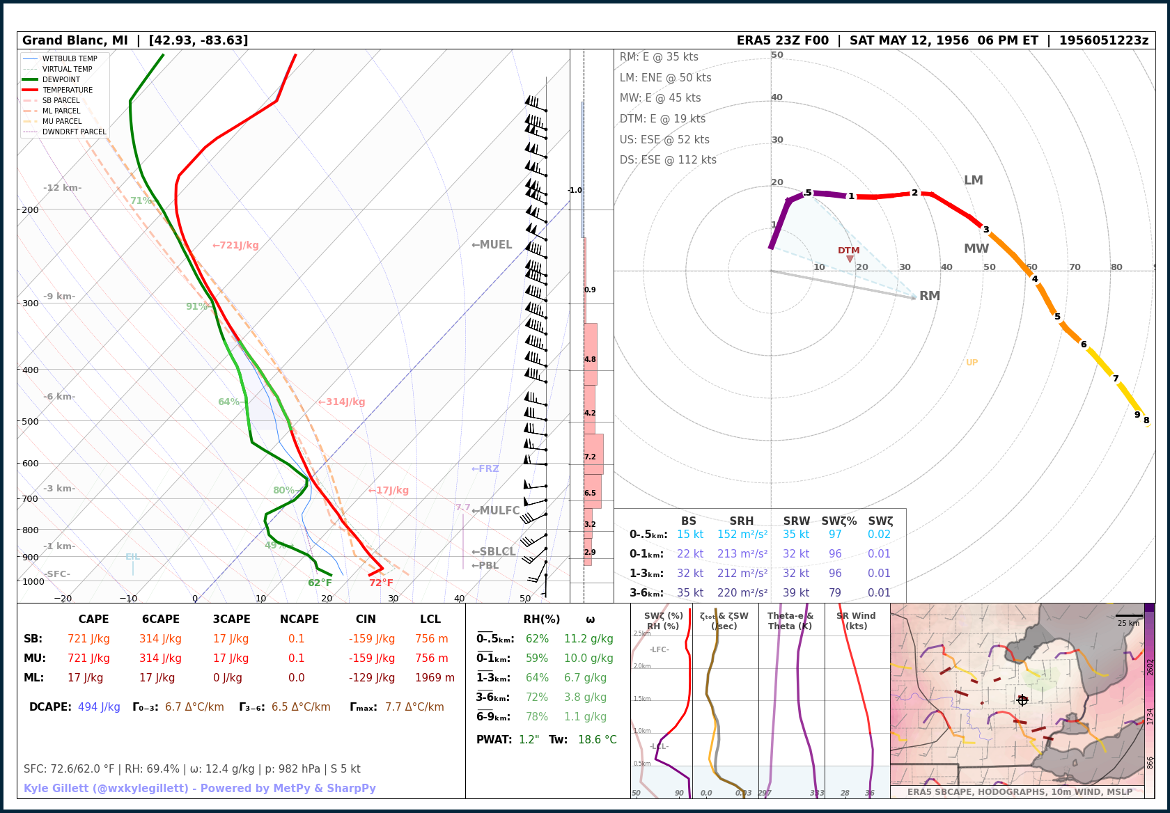
May 12, 1956 | Flint & Burton F4
May 12, 1956
Flint & Burton F4
EVENT LOCATION: Genesee County | Flint to Burton
EVENT DATE: May 12th, 1956 – 7:25 PM ET
NUMBER OF TORNADOES: 11
MAX TORNADO RATING(S): F4
MAX PATH LENGTH: 6.6 miles / 10.6 km
MAX WIDTH: 100 yd
MAX WIND: UND
MODEL DATA: MODEL: ECMWF ERA-5 (PRELIM BACK EXTENSION) F00 – RUN: 05/12/56/23 UTC – VAILD: 05/12/56/23 UTC – LOCATION: Grand Blanc, Mich (4 miles S Burton, Mich)
Read more about this event:
Jul 4, 1957 | Independence Day Oakland County F4
July 4, 1957
Independence Day Oakland County F4
EVENT LOCATION: Livingston & Oakland Counties | Brighton to Wixom to Farmington Hills to Royal Oak
EVENT DATE: July 4th, 1957 – 7:55 PM ET
NUMBER OF TORNADOES: 1
MAX TORNADO RATING(S): F4
MAX PATH LENGTH: 29.9 miles / 40.1 km
MAX WIDTH: 100 yd
MAX WIND: UND
MODEL DATA: MODEL: ECMWF ERA-5 (PRELIM BACK EXTENSION) F00 – RUN: 07/04/57/23 UTC – VAILD: 07/04/57/23 UTC – LOCATION: Novi, Mich (4 miles SSE Wixom, Mich)
Read more about this event:

– The 1960s –
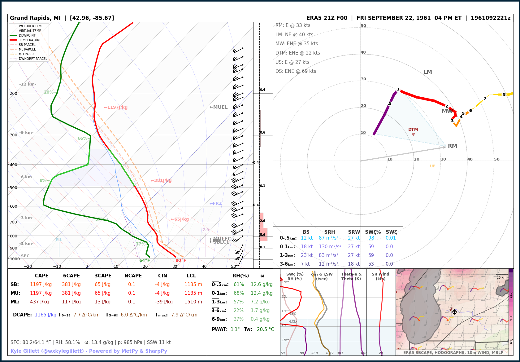
Sep 22, 1961 | Ottawa & Kent Counties F2
September 22, 1961
Ottawa & Kent Counties F2
EVENT LOCATION: Ottawa and Kent County | Marne to Fruit Ridge Center
EVENT DATE: September 22th, 1961 – 6:22 PM ET
NUMBER OF TORNADOES: 1
MAX TORNADO RATING(S): F2
MAX PATH LENGTH: 2.7 miles / 4.3 km
MAX WIDTH: 2000 yd
MAX WIND: UND
MODEL DATA: MODEL: ECMWF ERA-5 F00 – RUN: 09/22/61/21 UTC – VAILD: 09/22/61/21 UTC – LOCATION: Grand Rapids (8 miles SE Marne)
Read more about this event:
–
Apr 11, 1965 | Grand Rapids F4 – Palm Sunday ‘Super Outbreak’
April 11, 1965
Grand Rapids F4 – Palm Sunday ‘Super Outbreak’
EVENT LOCATION: Ottawa and Kent County | Allendale to Grand Rapids to Rockford
EVENT DATE: April 11th, 1965 – 6:54 PM ET
NUMBER OF TORNADOES: 12
MAX TORNADO RATING(S): F4
MAX PATH LENGTH: 20 miles / 32.1 km
MAX WIDTH: 300 yd
MAX WIND: UND
MODEL DATA: MODEL: ECMWF ERA-5 F00 – RUN: 04/11/65/23 UTC – VAILD: 04/11/65/23 UTC – LOCATION: Grand Rapids
Read more about this event:

Apr 11, 1965 | Southern Mich Long Track F4 – Palm Sunday ‘Super Outbreak’
April 11, 1965
Southern Mich Long Track F4 – Palm Sunday ‘Super Outbreak’
EVENT LOCATION: Steuben County, IN to Branch, Hillsdale, Lenawee, Washtenaw, Monroe Counties, MI
EVENT DATE: April 11th, 1965 – 7:03 PM ET to 8:15 PM ET
NUMBER OF TORNADOES: 12
MAX TORNADO RATING(S): F4
MAX PATH LENGTH: 90.3 miles / 145.3 km
MAX WIDTH: UND – a damage path up to 4 miles wide was found but this damage was caused by two tornadoes.
MAX WIND: UND
MODEL DATA: MODEL: ECMWF ERA-5 F00 – RUN: 04/12/65/00 UTC – VAILD: 04/12/65/00 UTC – LOCATION: Hudson, Mich (15 miles SSE Hillsdale, Mich)
Read more about this event:

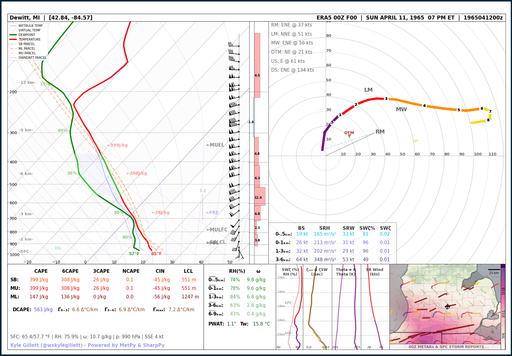
Apr 11, 1965 | DeWitt F4 – Palm Sunday ‘Super Outbreak’
April 11, 1965
DeWitt F4 – Palm Sunday ‘Super Outbreak’
EVENT LOCATION: Clinton and Shiawassee Counties | DeWitt to Bennington
EVENT DATE: April 11th, 1965 – 9:15 PM ET
NUMBER OF TORNADOES: 12
MAX TORNADO RATING(S): F4
MAX PATH LENGTH: 21 miles / 33.7 km
MAX WIDTH: 100 yd
MAX WIND: UND
MODEL DATA: MODEL: ECMWF ERA-5 F00 – RUN: 04/12/65/00 UTC – VAILD: 04/12/65/00 UTC – LOCATION: DeWitt, Mich
Read more about this event:
Jun 26, 1969 | Traverse City F3
June 26, 1969
Traverse City F3
EVENT LOCATION: Grand Traverse County | Traverse City
EVENT DATE: June 26th, 1969 – 3:30 PM ET
NUMBER OF TORNADOES: 2
MAX TORNADO RATING(S): F3
MAX PATH LENGTH: 6.4 miles / 10.2 km
MAX WIDTH: 600 yd
MAX WIND: UND
MODEL DATA: MODEL: ECMWF ERA-5 F00 – RUN: 06/26/69/19 UTC – VAILD: 06/26/69/19 UTC – LOCATION: Traverse City, Mich
Read more about this event:

– The 1970s –
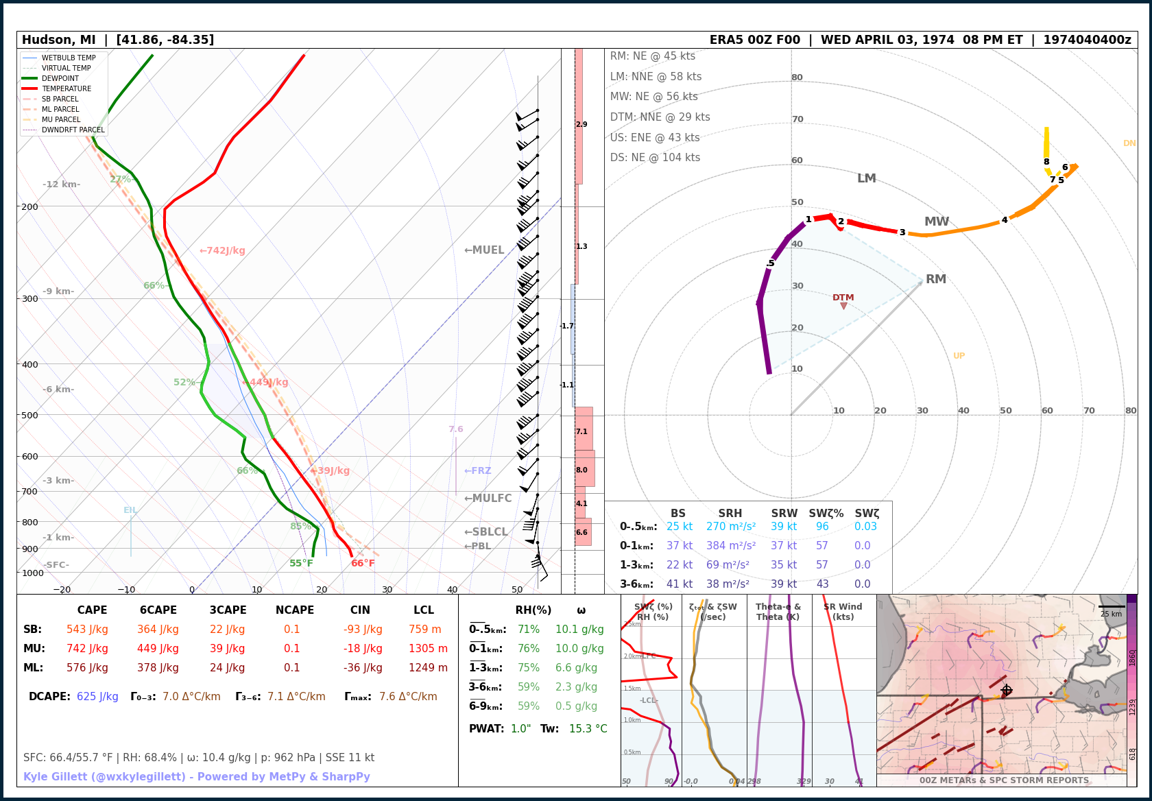
Apr 3, 1974 | Hillsdale to Liberty F2 (1974 ‘Super Outbreak’)
April 3, 1974
Hillsdale to Liberty F2 (1974 ‘Super Outbreak’)
EVENT LOCATION: Hillsdale & Jackson Counties | Hillsdale to Liberty Township
EVENT DATE: April 3rd, 1974 – 8:44 PM ET
NUMBER OF TORNADOES AROUND MICHIGAN: 5
MAX TORNADO RATING(S): F2
MAX PATH LENGTH: 19.3 miles / 30 km
MAX WIDTH: 440 yd
MAX WIND: UND
MODEL DATA: MODEL: ECMWF ERA-5 F00 – RUN: 04/04/74/00 UTC – VAILD: 04/04/74/00 UTC – LOCATION: Hudson, Mich (15 miles SE Hillsdale, Mich)
Read more about this event:
Mar 20, 1976 | Farmington Hills F4
March 20, 1976
Farmington Hills F4
EVENT LOCATION: Oakland County | Farmington Hills and West Bloomfield Township
EVENT DATE: March 20th, 1976 – 8:15 PM ET
NUMBER OF TORNADOES AROUND MICHIGAN: 5
MAX TORNADO RATING(S): F4
MAX PATH LENGTH: 3.8 miles / 6.1 km
MAX WIDTH: 117 yd
MAX WIND: UND
MODEL DATA: MODEL: ECMWF ERA-5 F00 – RUN: 03/20/76/01 UTC – VAILD: 03/20/76/01 UTC – LOCATION: Farmington Hills. Mich
Read more about this event:

Apr 2, 1977 | Bellevue to Eaton Rapids F4
April 2, 1977
Bellevue to Eaton Rapids F4
EVENT LOCATION: Eaton County – Bellevue to Eaton Rapids
EVENT DATE: April 2nd, 1977 – 4:06 PM ET
NUMBER OF TORNADOES AROUND MICHIGAN: 5
MAX TORNADO RATING(S): F4
MAX PATH LENGTH: ~18 miles / ~28.9 km
MAX WIDTH: 616 yds
MAX WIND: UND
MODEL DATA: MODEL: ECMWF ERA-5 F00 – RUN: 04/02/77/19 UTC – VAILD: 04/02/77/19 UTC – LOCATION: Brookfield, Mich (8 miles WSW Eaton Rapids, Mich)

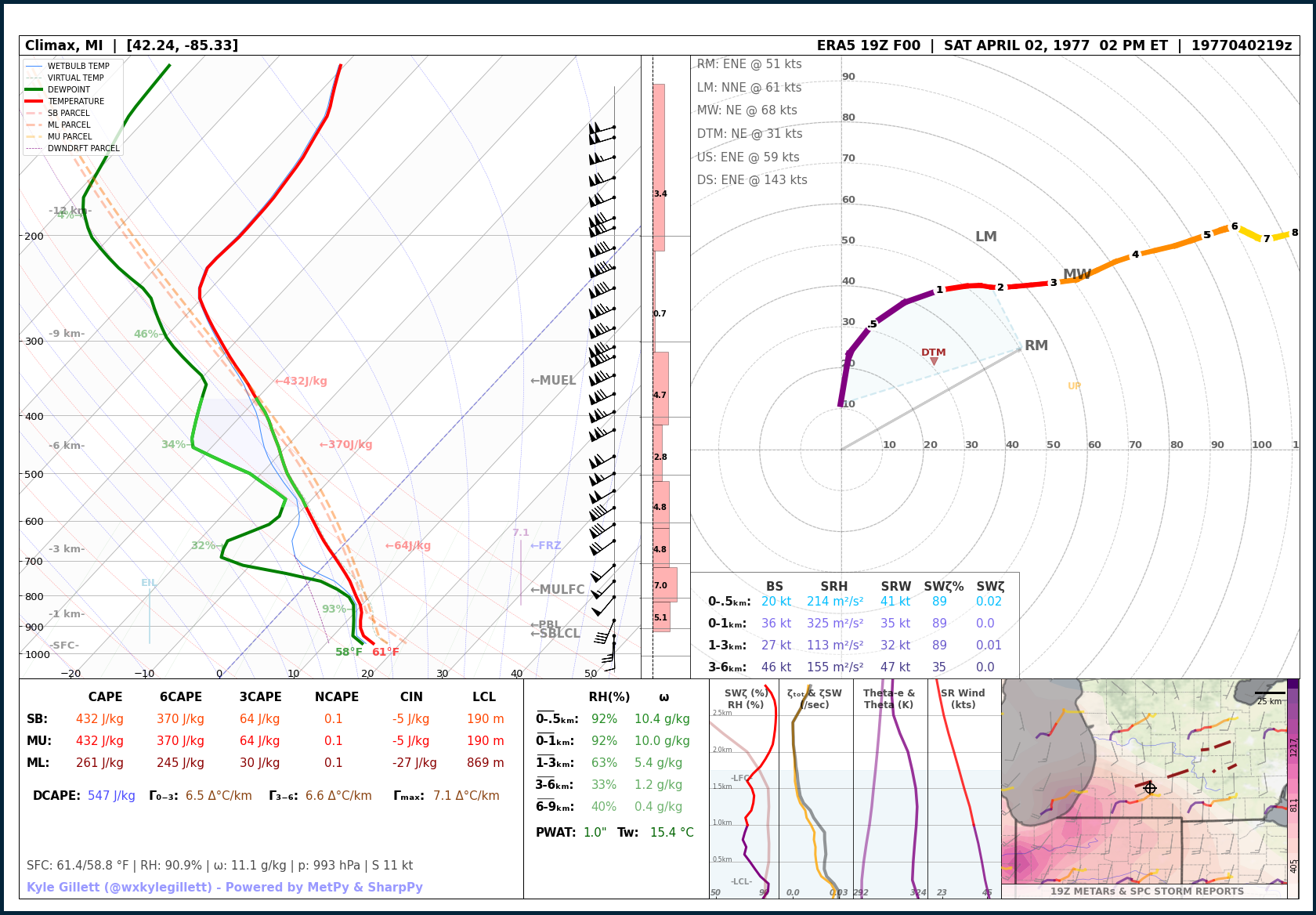
Apr 2, 1977 | Kalamazoo to Augusta F4
April 2, 1977
Kalamazoo to Augusta F4
EVENT LOCATION: Kalamazoo County | Kalamazoo to Augusta
EVENT DATE: April 2nd, 1977 – 3:30 PM ET
NUMBER OF TORNADOES AROUND MICHIGAN: 5
MAX TORNADO RATING(S): F4
MAX PATH LENGTH: 12.4 miles /19.9 km
MAX WIDTH: 183 yds
MAX WIND: UND
MODEL DATA: MODEL: ECMWF ERA-5 F00 – RUN: 04/02/77/19 UTC – VAILD: 04/02/77/19 UTC – LOCATION: Climax, Mich (7 miles SSE Augusta, Mich)
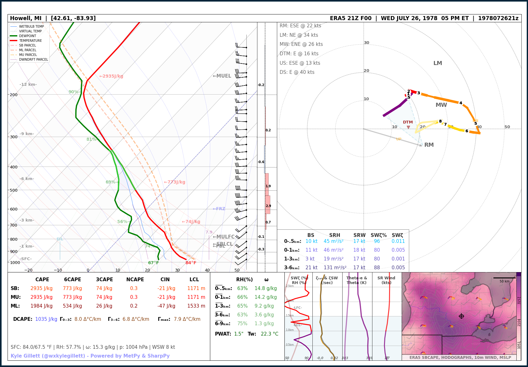
Jul 26, 1978 | Michigan Record Hail | 4.5 inches
July 26, 1978
Michigan Record Hail | 4.5 inches
EVENT LOCATION: Livingston County
EVENT DATE: July 26, 1978
MAX REPORTED HAIL SIZE: 4.5″
MODEL DATA: MODEL: ECMWF ERA-5 F00 – RUN: 07/26/78/21 UTC – VAILD: 07/26/78/21 UTC – LOCATION: Howell, Mich
MODEL DATA: MODEL: ECMWF ERA-5 F00 – RUN: 07/26/78/21 UTC – VAILD: 07/26/78/21 UTC – LOCATION: Howell, Mich
– The 1980s –
May 13, 1980 | Infamous Downtown Kalamazoo F3
May 13, 1980
Infamous Downtown Kalamazoo F3
EVENT LOCATION: Kalamazoo County | Kalamazoo
EVENT DATE: May 13th, 1980 – 3:58 PM ET
NUMBER OF TORNADOES AROUND MICHIGAN: 2
MAX TORNADO RATING(S): F3
MAX PATH LENGTH: 10.6 miles / 17 km
MAX WIDTH: 450 ft
MAX WIND: UND
MODEL DATA: MODEL: ECMWF ERA-5 F00 – RUN: 05/13/80/19 UTC – VAILD: 05/13/80/19 UTC – LOCATION: Portage, Mich (6 miles S Kalamazoo, Mich)
Read more about this event:

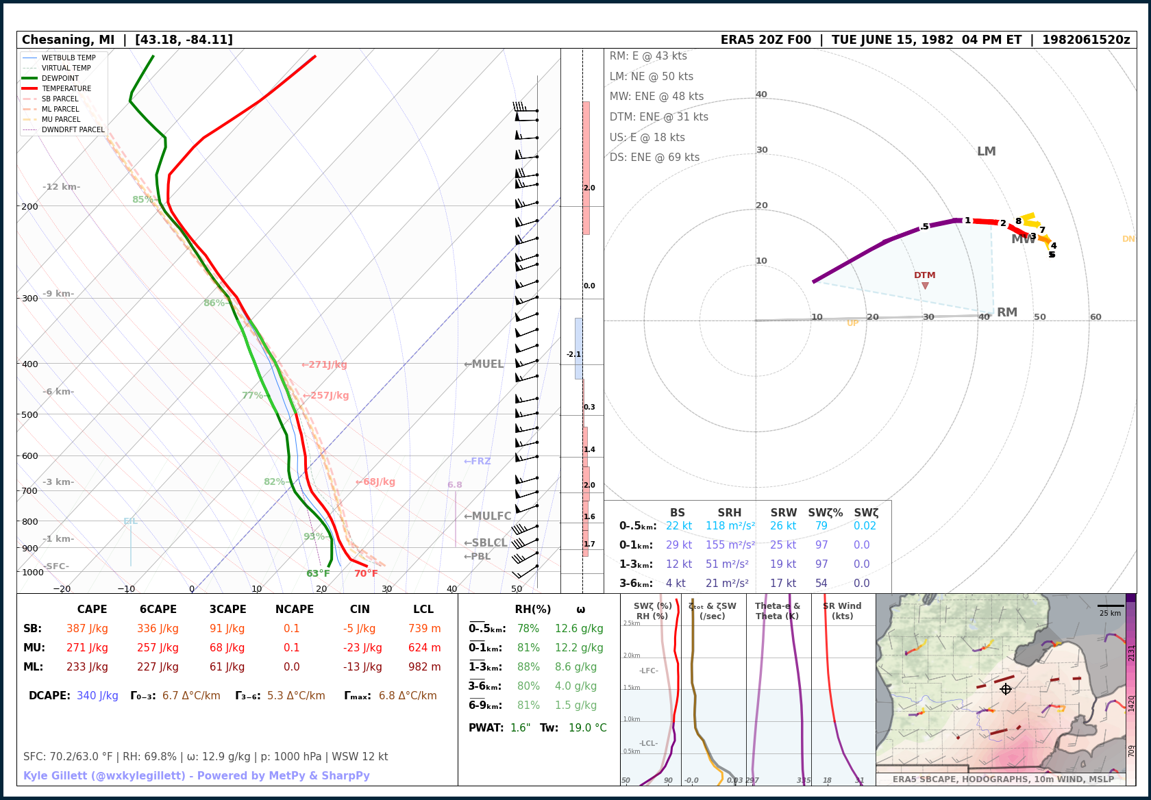
Jun 9, 1982 | Saginaw County F2
June 9, 1982
Saginaw County F2
EVENT LOCATION: Saginaw County | Lakefield to Saginaw
EVENT DATE: June 9th, 1982 – 4:25 PM ET
NUMBER OF TORNADOES AROUND MICHIGAN: 7
MAX TORNADO RATING(S): F2
MAX PATH LENGTH: 19 miles / 30.5 km
MAX WIDTH: 300 yd
MAX WIND: UND
MODEL DATA: MODEL: ECMWF ERA-5 F00 – RUN: 06/09/82/19 UTC – VAILD: 06/09/82/19 UTC – LOCATION: Chesaning, Mich (18 miles SW Saginaw, Mich)
Read more about this event:
Jun 12, 1984 | Bay & Huron Counties (Saginaw Bay) Long Track F3
June 12, 1984
Bay – Huron County Long Track F3
EVENT LOCATION: Bay County to the Saginaw Bay to Huron County – Bay City to Bay Port
EVENT DATE: June 12th, 1984 – 6:20 PM ET
NUMBER OF TORNADOES AROUND MICHIGAN: 1
MAX TORNADO RATING(S): F3
MAX PATH LENGTH: 38 miles / 61.1 km
MAX WIDTH: 500 ft
MAX WIND: UND
MODEL DATA: MODEL: ECMWF ERA-5 F00 – RUN: 06/12/84/22 UTC – VAILD: 06/12/84/22 UTC – LOCATION: Saginaw, Mich (12 miles SSW Bay City, Mich)
Read more about this event:

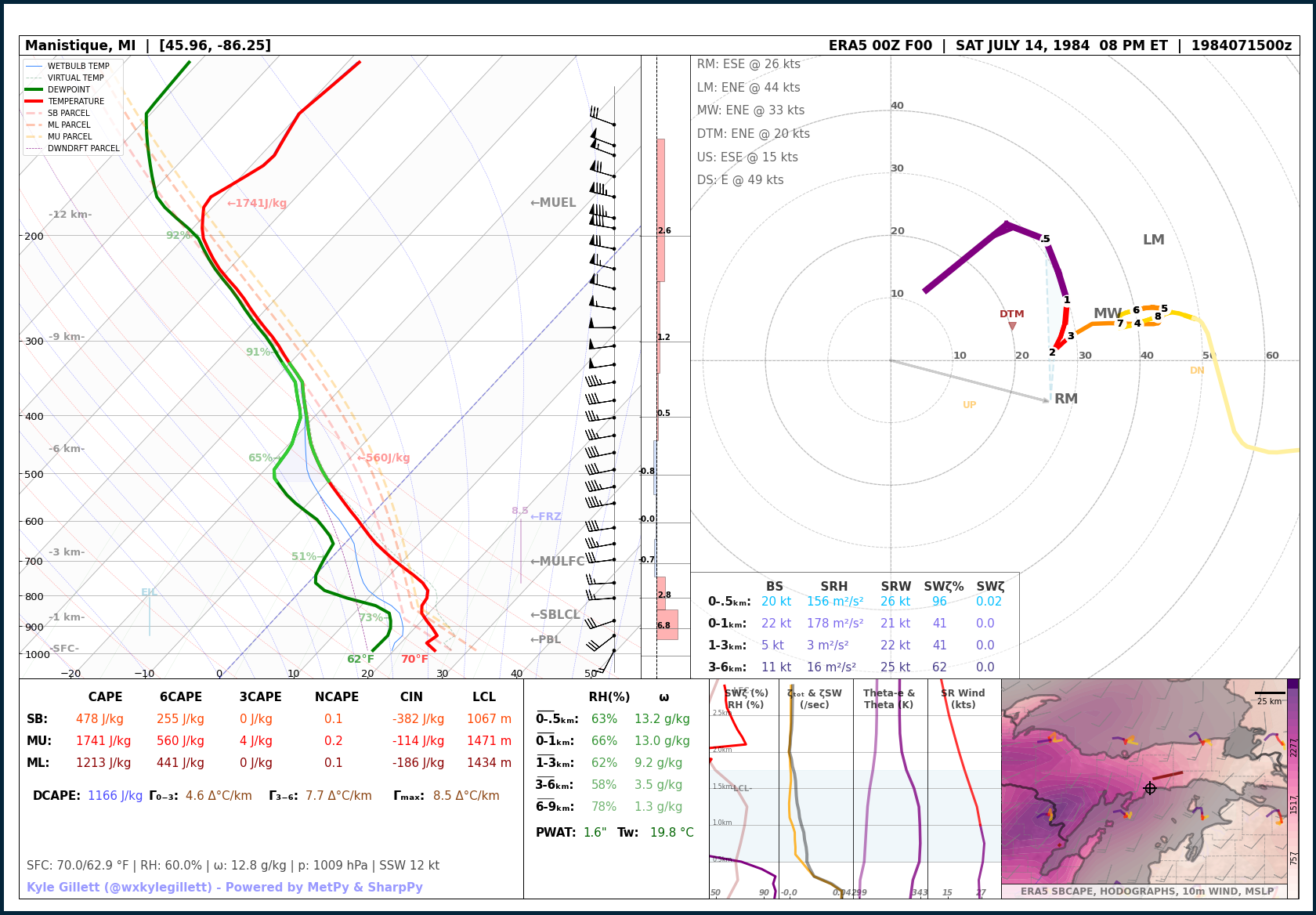
Jul 14, 1984 | Schoolcraft & Mackinac County F2
July 14, 1984
Schoolcraft & Mackinac County F2
EVENT LOCATION: Schoolcraft & Mackinac Counties – Hiawatha to Curtis
EVENT DATE: July 14th, 1984 – 8:00 PM ET
NUMBER OF TORNADOES AROUND MICHIGAN: 1
MAX TORNADO RATING(S): F3
MAX PATH LENGTH: 27 miles / 43.5 km
MAX WIDTH: 100 yd
MAX WIND: UND
MODEL DATA: MODEL: ECMWF ERA-5 F00 – RUN: 07/15/84/00 UTC – VAILD: 07/15/84/00 UTC – LOCATION: Manistique, Mich (10 miles S Hiawatha, Mich)
Read more about this event:
Jun 10, 1987 | Upper Peninsula – Quad-County Long Track F3
June 10, 1987
Upper Peninsula – Quad-County Long Track F3
EVENT LOCATION: Dickinson – Menominee – Delta – Schoolcraft Counties | Iron Mountian to Thompson
EVENT DATE: June 10th, 1987 – 8:05 PM ET
NUMBER OF TORNADOES AROUND MICHIGAN: 1
MAX TORNADO RATING(S): F3
MAX PATH LENGTH: 71 miles / 114.2 km
MAX WIDTH: 150 yd
MAX WIND: UND
MODEL DATA: MODEL: ECMWF ERA-5 F00 – RUN: 06/10/87/23 UTC – VAILD: 06/10/87/23 UTC – LOCATION: Menominee, Mich (48 miles SSW Escanaba, Mich)
Read more about this event:
– The 1990s –
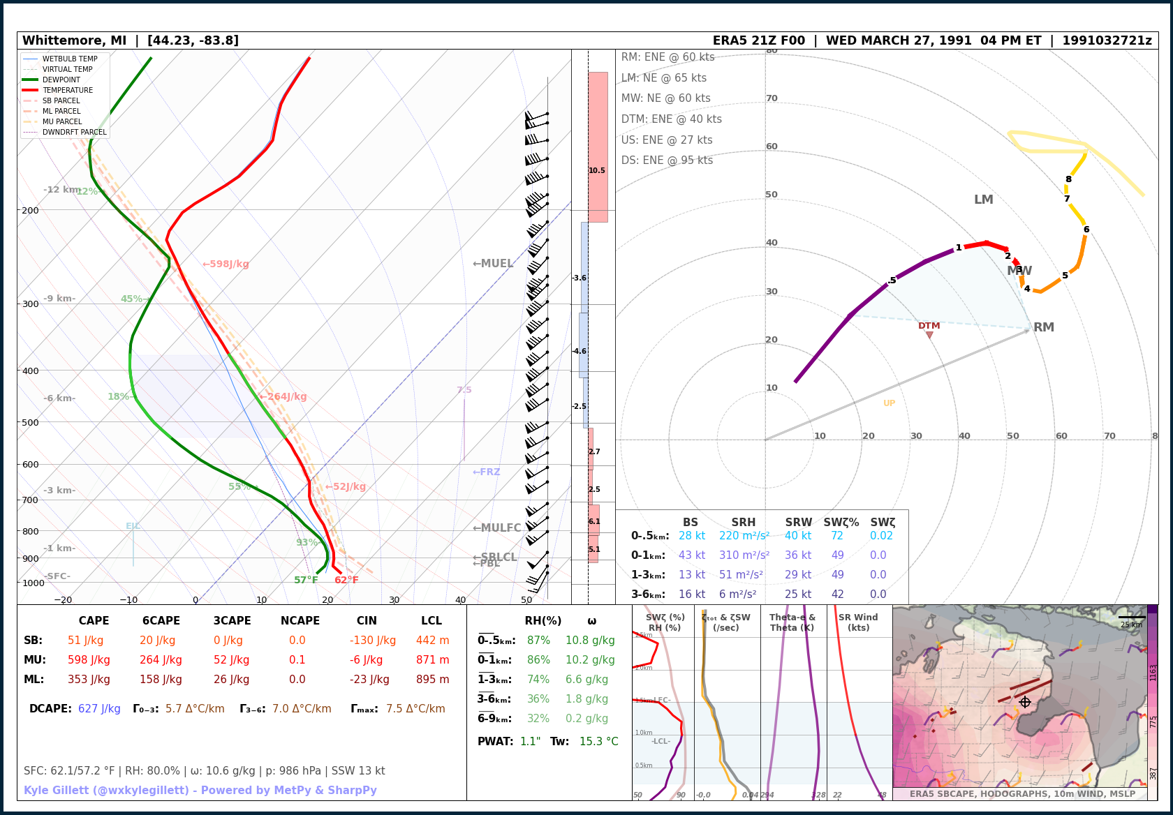
Mar 27, 1991 | Huron National Forest Pair of F3s (Michigan’s Largest Outbreak)
March 27, 1991
Huron National Forest Pair of F3s (Michigan’s Largest Outbreak)
EVENT LOCATION: Huron National Forecast – Ogemaw, Iosco, Alcona Counties
EVENT DATE: March 27th, 1991 – 6:00 to 6:40 PM ET
NUMBER OF TORNADOES AROUND MICHIGAN: 15 (Michigan’s largest 24hr tornado outbreak)
MAX TORNADO RATING(S): F3 (x2)
MAX PATH LENGTH: 35 miles / 56.3 km
MAX WIDTH: 100 yd
MAX WIND: UND
MODEL DATA: MODEL: ECMWF ERA-5 F00 – RUN: 03/27/91/21 UTC – VAILD: 03/27/91/21 UTC – LOCATION: Whittemore, Mich (20 miles SE Rose City, Mich)
Read more about this event:
–
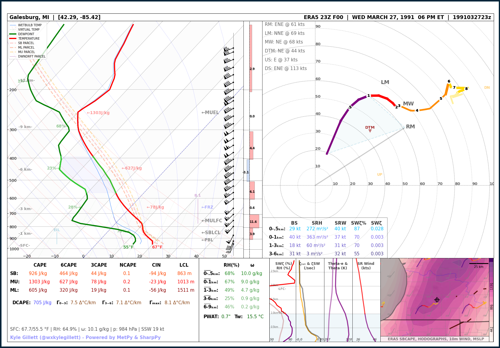
Mar 27, 1991 | Michigan Record Hail | 4.5 inches
March 27, 1991
Michigan Record Hail | 4.5 inches
EVENT LOCATION: Kalamazoo County
EVENT DATE: March 27th, 1991
MAX REPORTED HAIL SIZE: 4.5″
MODEL DATA: MODEL: ECMWF ERA-5 F00 – RUN: 03/27/91/22 UTC – VAILD:03/27/91/22 UTC – LOCATION: Galesburg, Mich
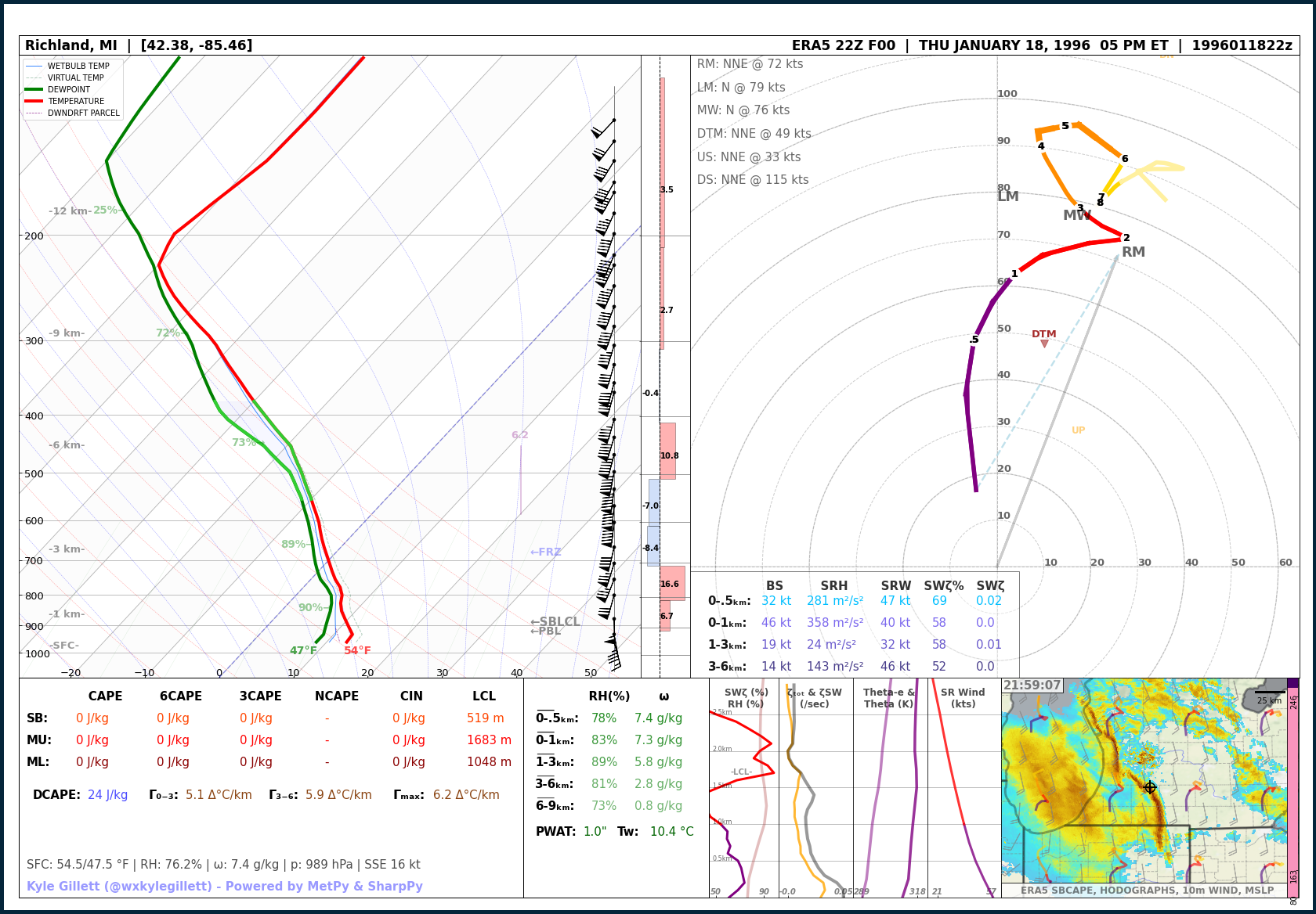
Jan 18, 1996 | Richland F0 (Michigan’s only January tornado)
January 18, 1996
Richland F0 (Michigan’s only January tornado)
EVENT LOCATION: Kalamazoo County | Richland
EVENT DATE: January 18th 1996 – 5:01 PM ET
NUMBER OF TORNADOES AROUND MICHIGAN: 1 (Michigan’s only January Tornado on record, 2nd ever during astronomical winter)
MAX TORNADO RATING(S): F0
MAX PATH LENGTH: 0.1 miles
MAX WIDTH: UND
MAX WIND: UND
MODEL DATA: MODEL: ECMWF ERA-5 F00 – RUN: 01/18/96/22 UTC – VAILD: 01/18/96/22 UTC – LOCATION: Richland, Mich
Read more about this event:
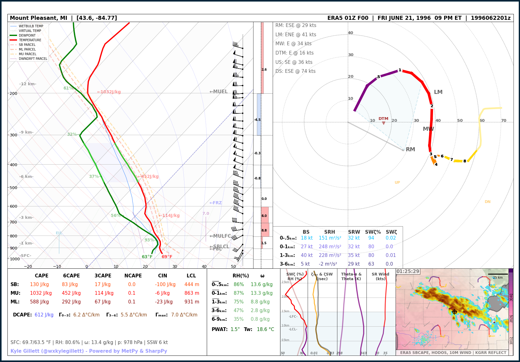
Jun 21, 1996 | Isabella County F1
June 21, 1996
Isabella County F1
EVENT LOCATION: Isabella County | Beal City
EVENT DATE: June 21st, 1996 – 9:26 PM ET
NUMBER OF TORNADOES AROUND MICHIGAN: 4
MAX TORNADO RATING(S): F1
MAX PATH LENGTH: 4.4 miles / 7 km
MAX WIDTH: 80 yd
MAX WIND: UND
MODEL DATA: MODEL: ECMWF ERA-5 F00 – RUN: 06/22/96/01 UTC – VAILD: 06/22/96/01 UTC – LOCATION: Mount Pleasant, Mich (8 miles SE Beal City, Mich)
Read more about this event:
Jun 21, 1996 | Frankenmuth F3
June 21, 1996
Frankenmuth F3
EVENT LOCATION: Saginaw County | Frankenmuth
EVENT DATE: June 21st, 1996 – 11:03 PM ET
NUMBER OF TORNADOES AROUND MICHIGAN: 4
MAX TORNADO RATING(S): F3
MAX PATH LENGTH: 1 miles / 1.6 km
MAX WIDTH: 100 yd
MAX WIND: UND
MODEL DATA: MODEL: ECMWF ERA-5 F00 – RUN: 06/22/96/03 UTC – VAILD: 06/22/96/03 UTC – LOCATION: Birch Run, Mich (8 miles SE Frankenmuth, Mich)
Read more about this event:

Jul 2, 1997 | Genesee County Pair of F3s (‘The Great Tornado Outbreak of 1997’)
July 2, 1997
Genesee County Pair of F3s (‘The Great Tornado Outbreak of 1997’)
EVENT LOCATION: Genesee County | Clio to SE of Clio
EVENT DATE: July 2nd, 1997 – 4:30 PM ET
NUMBER OF TORNADOES AROUND MICHIGAN: 14 (Michigan’s 2nd largest 24hr tornado outbreak)
MAX TORNADO RATING(S): F3 (x2)
MAX PATH LENGTH: 2 miles / 3.2 km
MAX WIDTH: 1000 yd
MAX WIND: UND
MODEL DATA: MODEL: ECMWF ERA-5 F00 – RUN: 07/02/97/20 UTC – VAILD: 07/02/97/20 UTC – LOCATION: Mount Morris, Mich (5 miles SSE Clio, Mich)
Read more about this event:
–

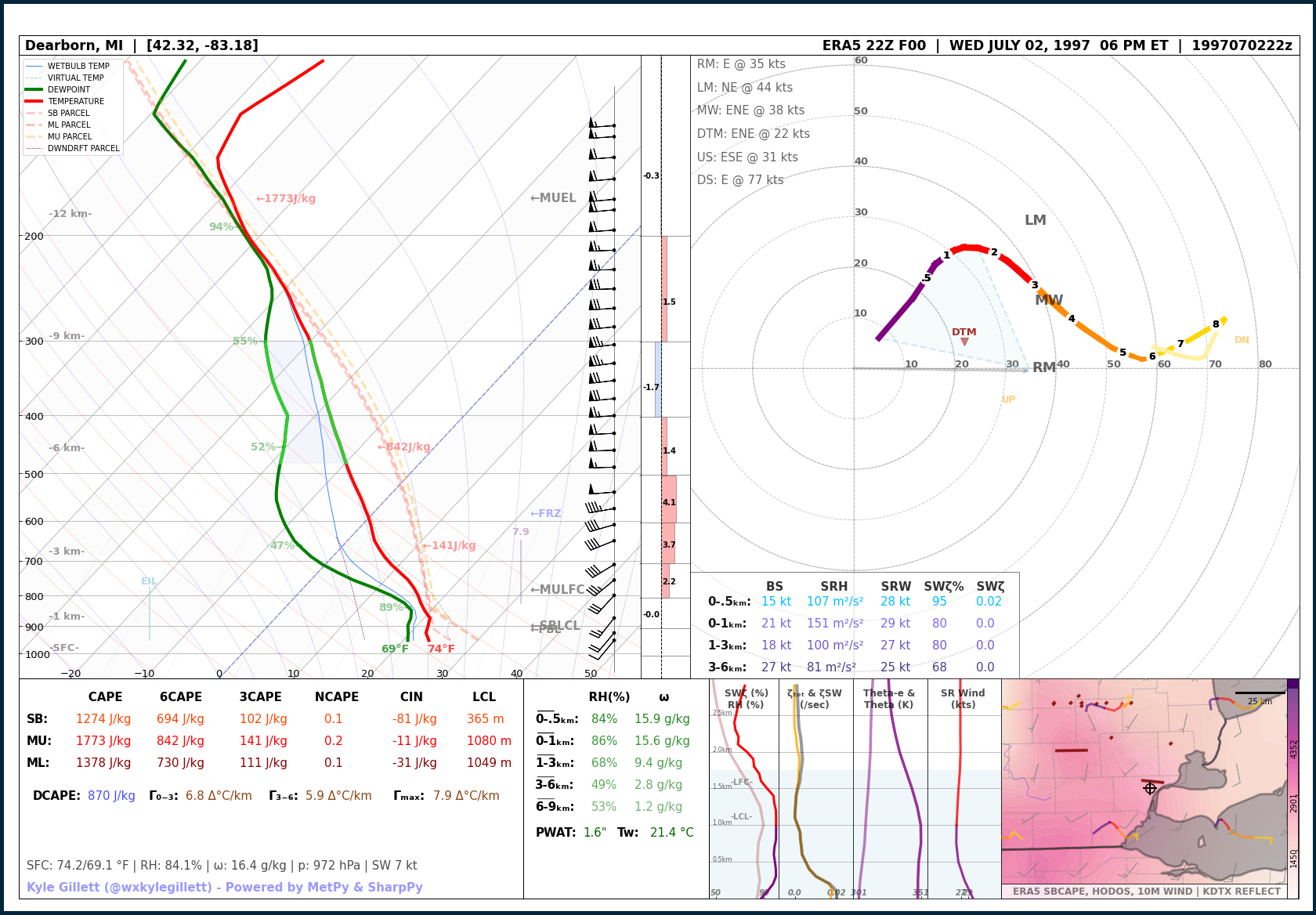
Jul 2, 1997 | Metro Detroit F2 (‘The Great Tornado Outbreak of 1997’)
July 2, 1997
Metro Detroit F2 (‘The Great Tornado Outbreak of 1997’)
EVENT LOCATION: Wayne County | Hamtramck
EVENT DATE: July 2nd, 1997 – 6:30 PM ET
NUMBER OF TORNADOES AROUND MICHIGAN: 14 (Michigan’s 2nd largest 24hr tornado outbreak)
MAX TORNADO RATING(S): F2
MAX PATH LENGTH: 6.7 miles / 10.7 km
MAX WIDTH: 2500 yd
MAX WIND: UND
MODEL DATA: MODEL: ECMWF ERA-5 F00 – RUN: 07/02/97/22 UTC – VAILD: 07/02/97/22 UTC – LOCATION: Dearborn, Mich (4 miles S Hamtramck, Mich)
Read more about this event:
Jul 23, 1999 | Mount Pleasant Brief F0
July 2, 1997
Metro Detroit F2 (‘The Great Tornado Outbreak of 1997’)
EVENT LOCATION: Isabella County | Mount Pleasant
EVENT DATE: July 23th, 1999 – 1:13 PM ET
NUMBER OF TORNADOES AROUND MICHIGAN: 2
MAX TORNADO RATING(S): F0
MAX PATH LENGTH: 0.1 miles / 0.1 km
MAX WIDTH: 10 yd
MAX WIND: UND
MODEL DATA: MODEL: ECMWF ERA-5 F00 – RUN: 07/23/99/17 UTC – VAILD: 07/23/99/17 UTC – LOCATION: Mount Pleasant, Mich
Read more about this event:
–

– The 2000s –
Jun 6, 2001 | Bi-State Long Track F3 (Indiana, Ohio, Michigan Outbreak)
June 6, 2001
Bi-State Long Track F3 (Indiana, Ohio, Michigan Outbreak)
EVENT LOCATION: Berrien, Cass, St. Joseph Counties | Bertrand to Cassopolis to Marcellus
EVENT DATE: October 24th, 2001 – 2:11 AM ET
NUMBER OF TORNADOES AROUND MICHIGAN: 4
MAX TORNADO RATING(S): F2
MAX PATH LENGTH: 47 miles / 75.6 km
MAX WIDTH: 1320 yds
MAX WIND: UND
MODEL DATA: MODEL: ECMWF ERA-5 F00 – RUN: 10/24/01/20 UTC – VAILD: 10/24/01/20 UTC – LOCATION: Edwardsburg, Mich (8 miles SSW Cassopolis, Mich)
Read more about this event:

Aug 22, 2003 | Webberville F2
August 22, 2003
Webberville F2
EVENT LOCATION: Ingham and Lenawee County | Webberville
EVENT DATE: August 22nd, 2003 – 8:55 PM ET
NUMBER OF TORNADOES AROUND MICHIGAN: 1
MAX TORNADO RATING(S): F2
MAX PATH LENGTH: 4.7 miles / 7.5 km
MAX WIDTH: 880 yd
MAX WIND: UND
MODEL DATA: MODEL: ECMWF ERA-5 F00 – RUN: 08/22/03/00 UTC – VAILD: 08/22/03/00 UTC – LOCATION: Vantown, Mich (9 miles SSE Webberville, Mich)
Read more about this event:

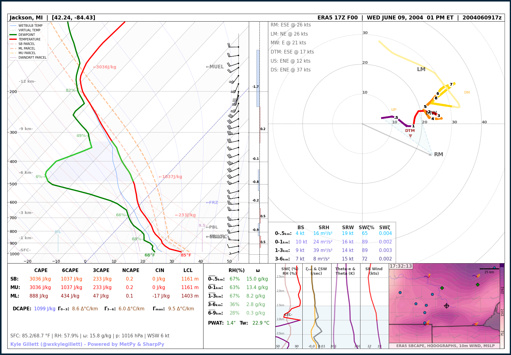
Jun 9, 2004 | Jackson County Significant Hail | 4.25 inches
June 9, 2004
Jackson County Significant Hail | 4.25 inches
EVENT LOCATION: Jackson County
EVENT DATE: June 9, 2004
MAX REPORTED HAIL SIZE: 4.25″
MODEL DATA: MODEL: ECMWF ERA-5 F00 – RUN: 06/09/04/17 UTC – VAILD: 06/09/04/17 UTC – LOCATION: Jackson, Mich
Aug 24, 2007 | Charlotte to Potterville EF3
August 24, 2007
Charlotte to Potterville EF3
EVENT LOCATION: Eaton County | Charlotte to Potterville
EVENT DATE: August 24th, 2007 – 4:25 PM ET
NUMBER OF TORNADOES AROUND MICHIGAN: 4
MAX TORNADO RATING(S): EF3
MAX PATH LENGTH: 6.5 miles / 10.4 km
MAX WIDTH: 300 yd
MAX WIND: UND
MODEL DATA: MODEL: ERA5 F00 – RUN: 08/24/07/20 UTC – VAILD: 08/24/07/20 UTC – LOCATION: Eaton Rapids, Mich (9 miles ESE Charlotte, Mich)
Read more about this event:

Oct 18, 2007 | Long Rapids EF2
October 18, 2007
Long Rapids EF2
EVENT LOCATION: Alpena County | NW of Long Rapids
EVENT DATE: October 18th, 2007 – 5:25 PM ET
NUMBER OF TORNADOES AROUND MICHIGAN: 10
MAX TORNADO RATING(S): EF2
MAX PATH LENGTH: 4.1 miles / 6.5 km
MAX WIDTH: 430 yd
MAX WIND: UND
MODEL DATA: MODEL: ERA5 F00 – RUN: 10/18/07/22 UTC – VAILD: 10/18/07/22 UTC – LOCATION: Long Rapids, Mich
Read more about this event:

– The 2010s –
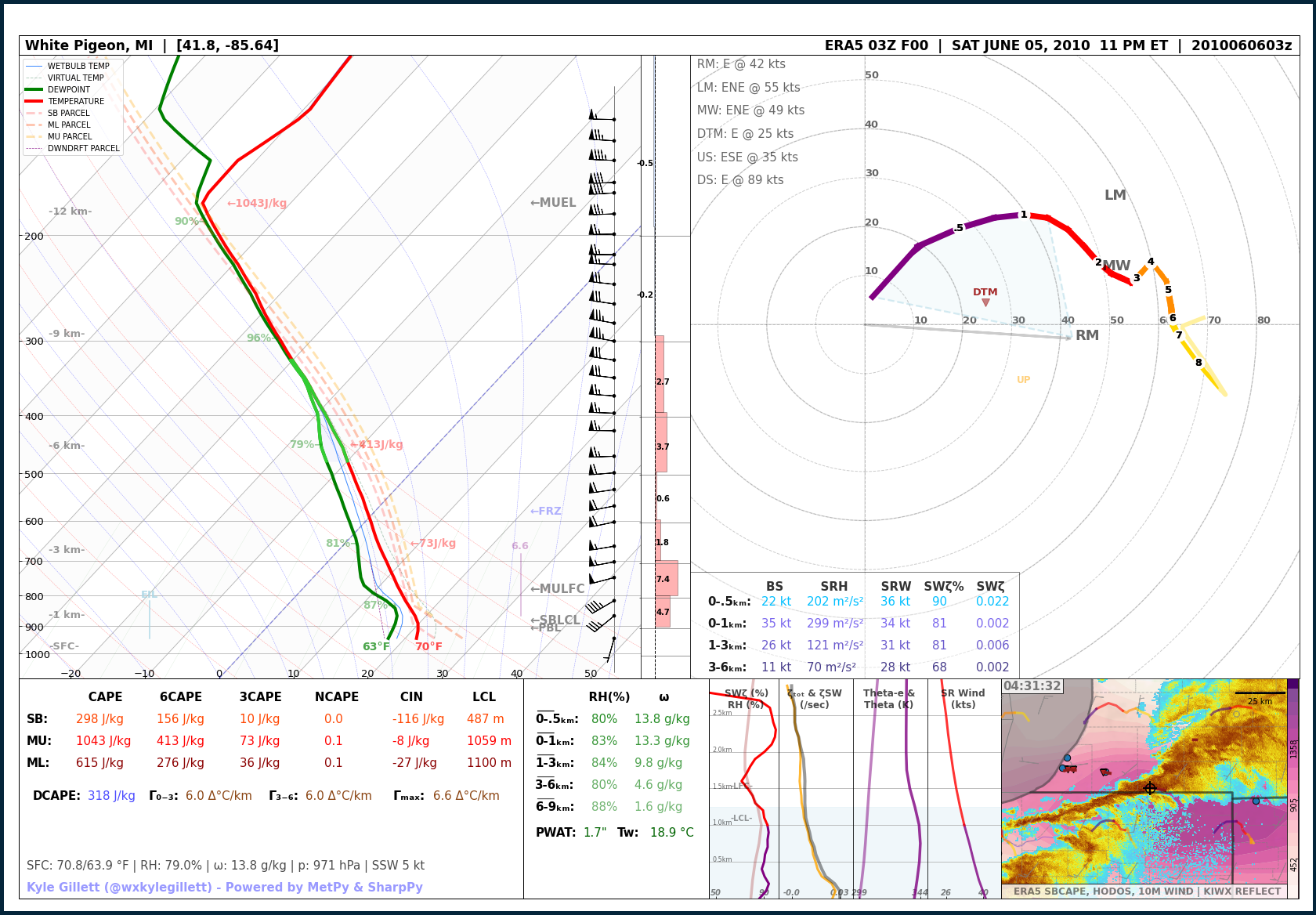
Jun 6, 2010 | White Pigeon, Michigan EF2 (Michigan, Ohio & Indiana ‘Mini-Outbreak’)
June 6, 2010
White Pigeon, Michigan EF2 (Michigan, Ohio & Indiana ‘Mini-Outbreak’)
EVENT LOCATION: St. Joseph County | White Pigeon
EVENT DATE: June 6th, 2010 – 12:32 AM ET
NUMBER OF TORNADOES AROUND MICHIGAN: 9
MAX TORNADO RATING(S): EF2
MAX PATH LENGTH: 9.4 miles / 15.1 km
MAX WIDTH: UND
MAX WIND: 135 mph
MODEL DATA: MODEL: ERA5 F00 – RUN: 06/06/10/03 UTC – VAILD: 06/06/10/03 UTC – LOCATION: White Pigeon, Mich
Read more about this event:
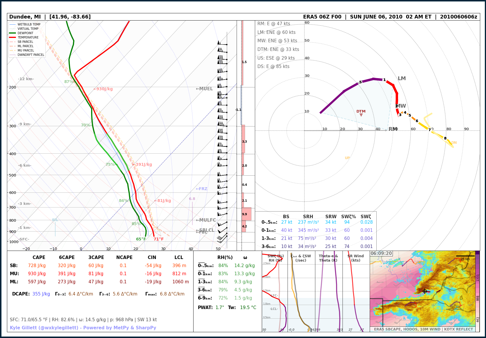
Jun 6, 2010 | Dundee, Michigan Overnight EF2 (Michigan, Ohio & Indiana ‘Mini-Outbreak’)
June 6, 2010
Dundee, Michigan Overnight EF2 (Michigan, Ohio & Indiana ‘Mini-Outbreak’)
EVENT LOCATION: Monroe County | Dundee
EVENT DATE: June 6th, 2010 – 2:11 AM ET
NUMBER OF TORNADOES AROUND MICHIGAN: 9
MAX TORNADO RATING(S): EF2
MAX PATH LENGTH: 13 miles / 20.9 km
MAX WIDTH: 800 yds
MAX WIND: 115 mph
MODEL DATA: MODEL: ERA5 F00 – RUN: 06/06/10/06 UTC – VAILD: 06/06/10/06 UTC – LOCATION: Dundee, Mich
Read more about this event:
Apr 26, 2011 | Allegan County EF-0 (2011 ‘Super-Outbreak’)
April 26, 2011
Allegan County EF-0 (2011 ‘Super-Outbreak’)
EVENT LOCATION: Allegan County | New Salem
EVENT DATE: April 26th, 2011 – 5:44 PM ET
NUMBER OF TORNADOES AROUND MICHIGAN: 1
MAX TORNADO RATING(S): EF0
MAX PATH LENGTH: 3.3 miles / 5.3 km
MAX WIDTH: 50 yds
MAX WIND: UND
MODEL DATA: MODEL: ERA5 F00 – RUN: 04/26/11/21 UTC – VAILD: 04/26/11/21 UTC – LOCATION: Dorr, Mich (4 miles SE New Salem, Mich)
Read more about this event:

Mar 15, 2012 | Dexter EF-3 (Only Violent Michigan Tornado during the 2010s)
March 15, 2012
Dexter EF-3 (Only Violent Michigan Tornado during the 2010s)
EVENT LOCATION: Washtenaw County | Dexter
EVENT DATE: March 15th, 2012 – 5:18 PM ET
NUMBER OF TORNADOES AROUND MICHIGAN: 2
MAX TORNADO RATING(S): EF3
MAX PATH LENGTH: 7.6 miles / 12.2 km
MAX WIDTH: 800 yds
MAX WIND: 140 mph
MODEL DATA: MODEL: ERA5 F00 – RUN: 04/26/11/21 UTC – VAILD: 04/26/11/21 UTC – LOCATION: Dorr, Mich (4 miles SE New Salem, Mich)
Read more about this event:

May 28, 2013 | Fenton, Michigan EF2 (Localized ‘Mini-Outbreak’)
May 28, 2013
Fenton, Michigan EF2 (Localized ‘Mini-Outbreak’)
EVENT LOCATION: Genesee County | Fenton to near Grand Blanc
EVENT DATE: May 28th, 2013 – 9:30 PM ET
NUMBER OF TORNADOES AROUND MICHIGAN: 5
MAX TORNADO RATING(S): EF2
MAX PATH LENGTH: 5.1 miles / 8.2 km
MAX WIDTH: 500 yds
MAX WIND: 115 mph
MODEL DATA: MODEL: RAP F00 – RUN: 05/29/13/01 UTC – VAILD: 05/29/13/01 UTC – LOCATION: Fenton, Mich
Read more about this event:

May 28, 2013 | Fenton, Michigan EF2 (Localized ‘Mini-Outbreak’) – DTX RAOB
May 28, 2013
Fenton, Michigan EF2 (Localized ‘Mini-Outbreak’)
EVENT LOCATION: Genesee County | Fenton to near Grand Blanc
EVENT DATE: May 28th, 2013 – 9:30 PM ET
NUMBER OF TORNADOES AROUND MICHIGAN: 5
MAX TORNADO RATING(S): EF2
MAX PATH LENGTH: 5.1 miles / 8.2 km
MAX WIDTH: 500 yds
MAX WIND: 115 mph
RAOB DATA: DTX (Detroit / White Lake Mich) | May 29th, 2013 – 00 UTC
Read more about this event:

Jun 22, 2015 | Birch Run EF2 – (Thumb ‘Mini-Outbreak’)
June 22, 2015
Birch Run EF2 – (Thumb ‘Mini-Outbreak’)
EVENT LOCATION: Saginaw to Tuscola Counties – Birch Run to Millington
EVENT DATE: June 22th, 2015 – 9:03 PM ET
NUMBER OF TORNADOES AROUND MICHIGAN: 5
MAX TORNADO RATING(S): F2
MAX PATH LENGTH: 11.1 miles / 17.8 km
MAX WIDTH: 400 yards
MAX WIND: 115 mph
MODEL DATA: MODEL: RAP F00 – RUN: 06/23/15/01 UTC – VAILD: 06/23/15/01 UTC – LOCATION: Clio, Mich (5 miles SSE Birch Run, Mich)
Read more about this event:

Jun 22, 2015 | Birch Run EF2 – (Thumb ‘Mini-Outbreak’) – DTX RAOB
June 22, 2015
Birch Run EF2 – (Thumb ‘Mini-Outbreak’)
EVENT LOCATION: Saginaw to Tuscola Counties – Birch Run to Millington
EVENT DATE: June 22th, 2015 – 9:03 PM ET
NUMBER OF TORNADOES AROUND MICHIGAN: 5
MAX TORNADO RATING(S): F2
MAX PATH LENGTH: 11.1 miles / 17.8 km
MAX WIDTH: 400 yards
MAX WIND: 115 mph
RAOB DATA: MODEL: DTX RAOB VAILD: 06/23/15/00 UTC – LOCATION: Detroit / White Lake, Michigan.
Read more about this event:

Aug 2, 2015 | Upper Michigan Record Hail | 4.25 inches
August 2, 2015
Upper Michigan Record Hail | 4.25 inches
EVENT LOCATION: Ogemaw County
EVENT DATE: August 2nd, 2004
MAX REPORTED HAIL SIZE: 4.25″
MODEL DATA: MODEL: ECMWF ERA-5 F00 – RUN: 08/02/15/20 UTC – VAILD: 08/02/15/20 UTC – LOCATION: West Branch, Mich

Dec 23, 2015 | Canton EF-1 (Michigan’s Only December Tornado)
December 23, 2015
Canton EF-1 (Michigan’s Only December Tornado)
EVENT LOCATION: Wayne County | Canton
EVENT DATE: December 23rd, 2015 – 6:43 PM ET
NUMBER OF TORNADOES AROUND MICHIGAN: 1 (Michigan’s Only December tornado on record, 3rd ever during astronomical winter)
MAX TORNADO RATING(S): EF-1
MAX PATH LENGTH: 2 miles / 17.8 km
MAX WIDTH: 100 yards
MAX WIND: 90 mph
MODEL DATA: MODEL: RAP F00 – RUN: 12/23/15/23 UTC – VAILD: 12/23/15/23 UTC – LOCATION: Westland, Mich (3 miles SE Canton, Mich)
Read more about this event:

Aug 20, 2016 | Allegan County EF1 (West Michigan QLCS ‘Mini-Outbreak’)
August 20, 2016
Allegan County EF1 (West Michigan QLCS ‘Mini-Outbreak’)
EVENT LOCATION: Allegan County | Allegan
EVENT DATE: June 21st, 1996 – 1:42 PM ET
NUMBER OF TORNADOES AROUND MICHIGAN: 6
MAX TORNADO RATING(S): EF1
MAX PATH LENGTH: 12.8 miles / 20.5 km
MAX WIDTH: 100 yd
MAX WIND: 110 mph
MODEL DATA: MODEL: RAP F00 – RUN: 06/22/96/01 UTC – VAILD: 06/22/96/01 UTC – LOCATION: Mount Pleasant, Mich (8 miles SE Beal City, Mich)
Read more about this event:

Mar 14, 2019 | Perry to Lennon EF2
March 14, 2019
Perry to Lennon EF2
EVENT LOCATION: Shiawassee County | Perry to Durand to Lennon
EVENT DATE: March 14th, 2019 – 6:45 to 7:05 PM ET
NUMBER OF TORNADOES AROUND MICHIGAN: 4
MAX TORNADO RATING(S): EF2
MAX PATH LENGTH: 18.2 miles / 29.2 km
MAX WIDTH: 700 yds
MAX WIND: 125 mph
MODEL DATA: MODEL: RAP F00 – RUN: 03/14/19/23 UTC – VAILD: 03/14/19/23 UTC – LOCATION: Perry, Mich
Read more about this event:

– The 2020s –
Jun 26, 2021 – Port Austin, Michigan EF2
June 26, 2021
Port Austin, Michigan EF2
EVENT LOCATION: Huron County | Port Austin
EVENT DATE: June 26th, 2021 – 5:49 PM ET
NUMBER OF TORNADOES AROUND MICHIGAN: 1
MAX TORNADO RATING(S): EF3
MAX PATH LENGTH: 6.8 miles / 10.4 km
MAX WIDTH: 400 yds
MAX WIND: 120 mph
MODEL DATA: MODEL: RAP F00 – RUN: 06/26/21/21 UTC – VAILD: 06/26/21/21 UTC – LOCATION: Kinde, Mich (7 miles S Port Austin, Mich)
Read more about this event:
NWS DTX: https://www.weather.gov/dtx/MetroDetroitFlooding_PortAustinTornado_June2021

Jul 24, 2021 | White Lake, Michigan Highly Deviant EF1
July 24, 2021
White Lake, Michigan Highly Deviant EF1
EVENT LOCATION: Oakland County | White Lake Township
EVENT DATE: July 24th, 2021 – 7:45 PM ET
NUMBER OF TORNADOES AROUND MICHIGAN: 4
MAX TORNADO RATING(S): EF2
MAX PATH LENGTH: 1.8 miles / 2.8 km
MAX WIDTH: 400 yds
MAX WIND: 100 mph
MODEL DATA: MODEL: RAP F00 – RUN: 07/25/21/00 UTC – VAILD: 07/25/21/00 UTC – LOCATION: Pontiac, Mich (10 miles SE White Lake Township, Mich)
Read more about this event:
NWS DTX: https://www.weather.gov/dtx/Severe-Thunderstorms-and-Tornadoes-July-24-2021

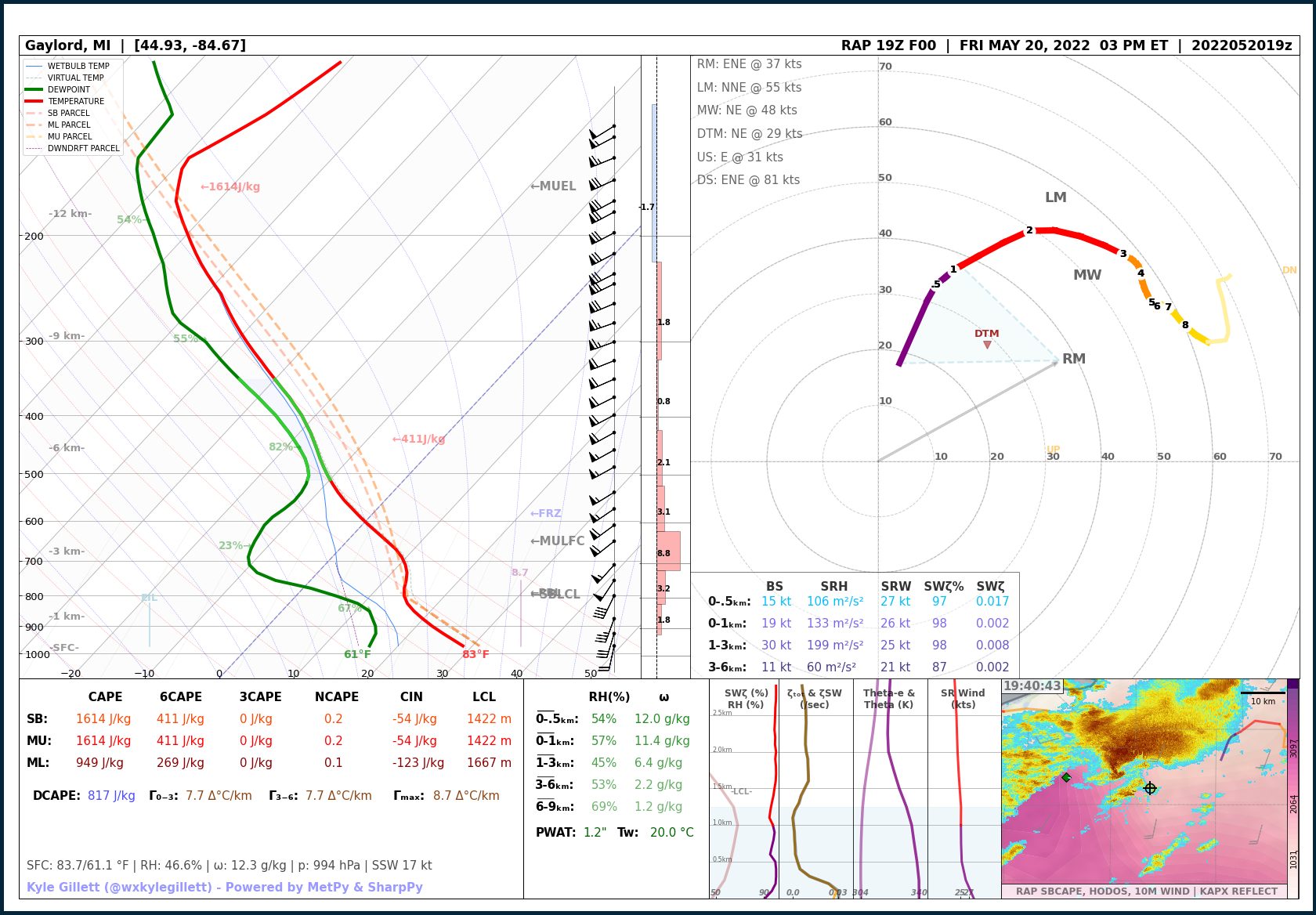
May 20, 2022 | Gaylord, Michigan EF3
May 20, 2022
Gaylord, Michigan EF3
EVENT LOCATION: Ostego County – Gaylord
EVENT DATE: May 20th, 2022 – 3:35 PM ET
NUMBER OF TORNADOES AROUND MICHIGAN: 1
MAX TORNADO RATING(S): EF3
MAX PATH LENGTH: 17.8 miles / 28.6 km
MAX WIDTH: 200 yds
MAX WIND: 150 mph
MODEL DATA: MODEL: RAP F00 – RUN: 05/20/22/19 UTC – VAILD: 05/20/22/19 UTC – LOCATION: Ostego Lake, Mich (9 miles S Gaylord, Mich)
Read more about this event:
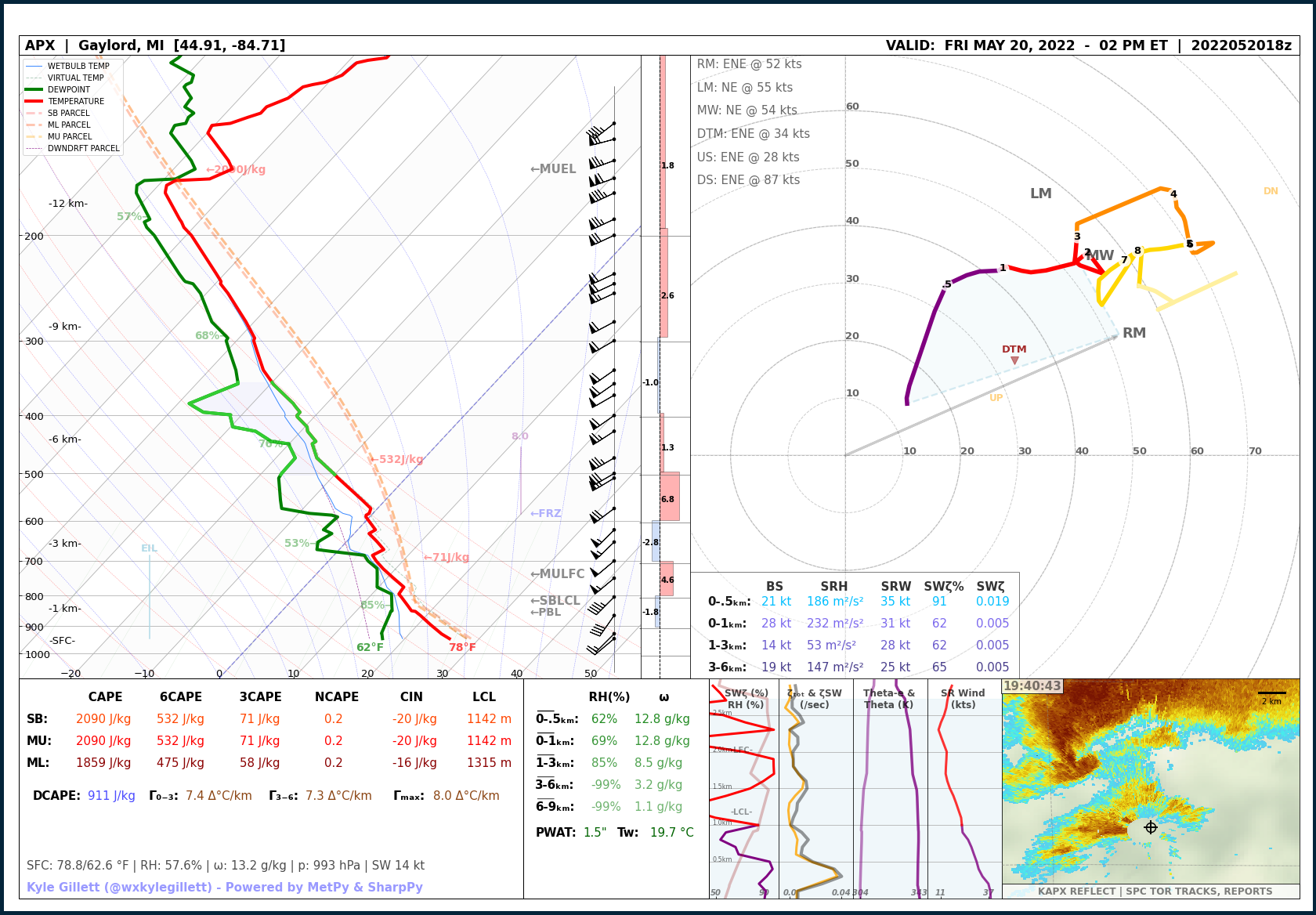
May 20, 2022 | Gaylord, Michigan EF3 – APX RAOB
May 20, 2022
Gaylord, Michigan EF3
EVENT LOCATION: Ostego County – Gaylord
EVENT DATE: May 20th, 2022 – 3:35 PM ET
NUMBER OF TORNADOES AROUND MICHIGAN: 1
MAX TORNADO RATING(S): EF3
MAX PATH LENGTH: 17.8 miles / 28.6 km
MAX WIDTH: 200 yds
MAX WIND: 150 mph
RAOB DATA: APX (Gaylord, Mich) | May 20th, 2022 – 18 UTC
Read more about this event:
Apr 1, 2023 | Dundee, Michigan Unexpected EF0
April 1, 2023
Dundee, Michigan Unexpected EF0
EVENT LOCATION: Monroe County | Dundee
EVENT DATE: April 1st, 2023 – 11:03 AM ET
NUMBER OF TORNADOES AROUND MICHIGAN: 1
MAX TORNADO RATING(S): EF0
MAX PATH LENGTH: 7.3 miles / 11.7 km
MAX WIDTH: 75 yds
MAX WIND: 80 mph
MODEL DATA: MODEL: RAP F00 – RUN: 04/01/23/15 UTC – VAILD: 04/01/23/15 UTC – LOCATION: Dundee, Mich
Read more about this event:
NWS DTX: https://www.weather.gov/dtx/DundeeTornadoApril1_2023

Jun 15, 2023 | Detroit Beech EF-1
June 15, 2023
Detroit Beech EF-1
EVENT LOCATION: Monroe County | Detroit Beach
EVENT DATE: June 15th, 2023 – 6:09 PM ET
NUMBER OF TORNADOES AROUND MICHIGAN: 1
MAX TORNADO RATING(S): EF1
MAX PATH LENGTH: 4.7 miles / 7.5 km
MAX WIDTH: 400 yds
MAX WIND: 90 mph
MODEL DATA: MODEL: RAP F00 – RUN: 06/15/23/22 UTC – VAILD: 06/15/23/22 UTC – LOCATION: Detroit, Mich
Read more about this event:
NWS DTX: https://www.weather.gov/dtx/severestormsanddetroitbeachtornado_june15_2023

Jul 12, 2023 | Colon EF-1
July 12, 2023
Colon EF-1
EVENT LOCATION: St. Joseph County | Colon
EVENT DATE: June 12th, 2023 – 11:09 PM ET
NUMBER OF TORNADOES AROUND MICHIGAN: 1
MAX TORNADO RATING(S): EF1
MAX PATH LENGTH: 2.92 miles / 4.6 km
MAX WIDTH: 50 yds
MAX WIND: 90 mph
MODEL DATA: MODEL: RAP F00 – RUN: 07/13/23/03 UTC – VAILD: 07/13/23/03 UTC – LOCATION: Mattenson, Mich
Read more about this event:

Jul 14, 2023 | Lexington Wedge EF-0
July 14, 2023
Lexington Wedge EF-0
EVENT LOCATION: Sanilac County | Applegate-Lexington
EVENT DATE: June 14th, 2023 – 3:24 PM ET
NUMBER OF TORNADOES AROUND MICHIGAN: 1
MAX TORNADO RATING(S): EF0
MAX PATH LENGTH: 4.9 miles / 7.8 km
MAX WIDTH: 450 yds (quarter-mile wide)
MAX WIND: 85 mph
MODEL DATA: MODEL: RAP F00 – RUN: 07/14/23/19 UTC – VAILD: 07/14/23/19 UTC – LOCATION: Croswell, Mich
Read more about this event:

Jul 26, 2023 | Stockbridge Pair of EF-0s
July 26, 2023
Stockbridge Pair of EF-0s
EVENT LOCATION: Jackson & Livingston Counties | Near Stockbridge
EVENT DATE: June 26th, 2023 – 2:39 PM ET
NUMBER OF TORNADOES AROUND MICHIGAN: 2
MAX TORNADO RATING(S): EF0
MAX PATH LENGTH: 1.5 miles / 2.4 km
MAX WIDTH: 150 yds
MAX WIND: 80 mph
MODEL DATA: MODEL: MODEL: RAP F00 – RUN: 07/26/23/19 UTC – VAILD: 07/26/23/19 UTC – LOCATION: Unadilla, Mich
Read more about this event:

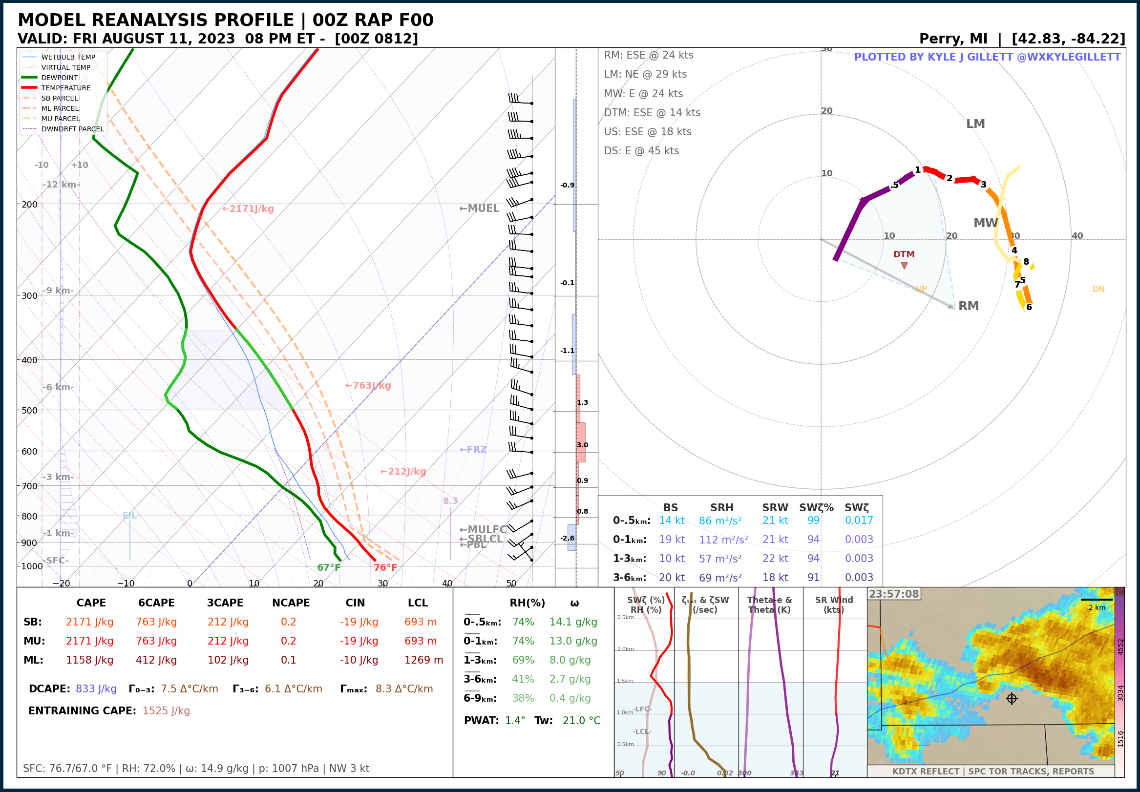
Aug 11, 2023 | Downtown Perry EF-1
August 11, 2023
Downtown Perry EF-1
EVENT LOCATION: Shiawassee County | Perry
EVENT DATE: August 11th, 2023 – 8:03 PM ET
NUMBER OF TORNADOES AROUND MICHIGAN: 1
MAX TORNADO RATING(S): EF1
MAX PATH LENGTH: 3 miles / 4.8 km
MAX WIDTH: 430 yds
MAX WIND: 95 mph
MODEL DATA: MODEL: RAP F00 – RUN: 08/12/23/00 UTC – VAILD: 08/12/23/00 UTC – LOCATION: Perry, Mich
Read more about this event:
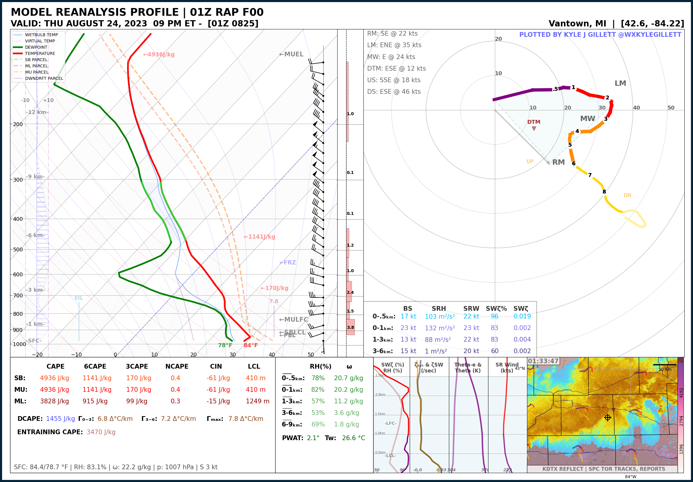
Aug 24, 2023 | Alpine Twp. EF-1
August 24, 2023
Alpine Twp. EF-1
EVENT LOCATION: Kent County | Alpine & Plainfield Townships
EVENT DATE: August 24th, 2023 – 8:15 PM ET
NUMBER OF TORNADOES AROUND MICHIGAN: 7
MAX TORNADO RATING(S): EF1
MAX PATH LENGTH: 8.7 miles / 14 km
MAX WIDTH: 100 yds
MAX WIND: 110 mph
MODEL DATA: MODEL: RAP F00 – RUN: 08/25/23/00 UTC – VAILD: 08/25/23/00 UTC – LOCATION: Ada, Mich
Read more about this event:

Aug 24, 2023 | Williamston-Webberville EF-2
August 24, 2023
Williamston-Webberville EF-2
EVENT LOCATION: Ingham & Livingston County | Near Williamston to near Webberville
EVENT DATE: August 24th, 2023 – 9:29 PM ET
NUMBER OF TORNADOES AROUND MICHIGAN: 7
MAX TORNADO RATING(S): EF-2
MAX PATH LENGTH: 12 miles / 19.3 km
MAX WIDTH: 500 yds
MAX WIND: 125 mph
MODEL DATA: MODEL: RAP F00 – RUN: 08/25/23/01 UTC – VAILD: 08/25/23/01 UTC – LOCATION: Vantown, Mich
Read more about this event:
Feb 28, 2024 | Marshall Overnight EF-1
Feb. 28, 2024
Marshall Overnight EF-1
EVENT LOCATION: Calhoun County | Northeast of Marshall
EVENT DATE: Feb 28th, 2024, 12:28-12:40 AM ET
NUMBER OF TORNADOES AROUND MICHIGAN: 2
MAX TORNADO RATING(S): EF-1
MAX PATH LENGTH: 5.5 miles / 8.8 km
MAX WIDTH: 300 yds
MAX WIND: 110 mph
MODEL DATA: MODEL: RAP F00 – RUN: 02/28/24/05 UTC – VAILD: 02/28/24/05 UTC – LOCATION: Marshall, Mich
Read more about this event:

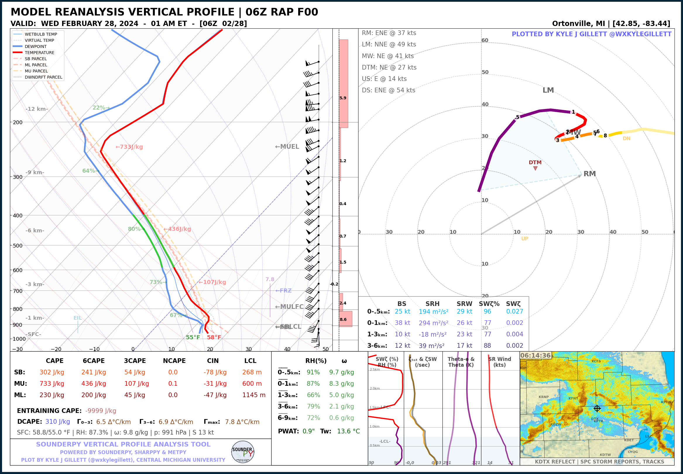
Feb 28, 2024 | Grand Blanc Overnight EF-2
Feb. 28, 2024
Grand Blanc Overnight EF-2
EVENT LOCATION: Genesee County | Grand Blanc
EVENT DATE: Feb 28th, 2024, 1:12-1:22 AM ET
NUMBER OF TORNADOES AROUND MICHIGAN: 2
MAX TORNADO RATING(S): EF-2
MAX PATH LENGTH: 5.8 miles / 9.3 km
MAX WIDTH: 450 yds
MAX WIND: 115 mph
MODEL DATA: MODEL: RAP F00 – RUN: 02/28/24/06 UTC – VAILD: 02/28/24/06 UTC – LOCATION: Ortonville, Mich
Read more about this event:
REANALYSIS DATA DISCLAIMER
Please note that the plots found on this page use MODELED REANALYSIS data from the RAP/RUC (2005-present), ERA-5 (1940-present) – i.e. not actual observations of the atmosphere*. Because of this, the plots provided here may not be entirely representative of the actual atmosphere that existed at the time & location of these reanalyzed plots. However, these reanalysis data provide a vertical profile that should closely resemble that of the actual atmosphere at the time. Reanalysis data are subject to the parameterization and schemes of the respective model. Plot time and location for each plot are determined by the author in order to best reflect an accurate, uncontaminated, and as-representative-as-possible profile.
*A few cases in this library are actual RAOB profiles (marked RAOB) from NWS launch sites around the time of nearby tornado events.
Note that there have been no modifications to the raw model output. Some interpolation operations take place to simplify parameter calculation and data plotting. Parameter calculations are subject to the author’s discretion.
This archive is meant to act as a library of soundings that represent notable Michigan tornado environments in order to aid CMU student forecasters in tornadic-environment pattern recognition in the state of Michigan.
Important note: vertical profiles (soundings) are not the only data forecasters should use to analyze meteorological conditions and weather phenomena. Other data sources such as surface analysis, mesoanalysis, and upper-air data should be considered but are not provided here. Check out this page for additional archive data resources.
RAP model data comes from the NOAA NCAR THREDDS data server. ERA-5 data comes from the ECMWF CDS service. Tornado stat data comes from NOAA SPC / NCEI & NOAA NWS.
The author of this page is Kyle Gillett.
Powered by SounderPy.
Acknowledgments: Cameron Nixon, Sam Brandt, Dan Butler, Ryan May. MetPy, SharpPy, Unidata.
Read more about the RAP MODEL DATA. Read more about ERA-5 MODEL DATA.
MICHIGAN TORNADO SOUNDING ARCHIVE GUIDE
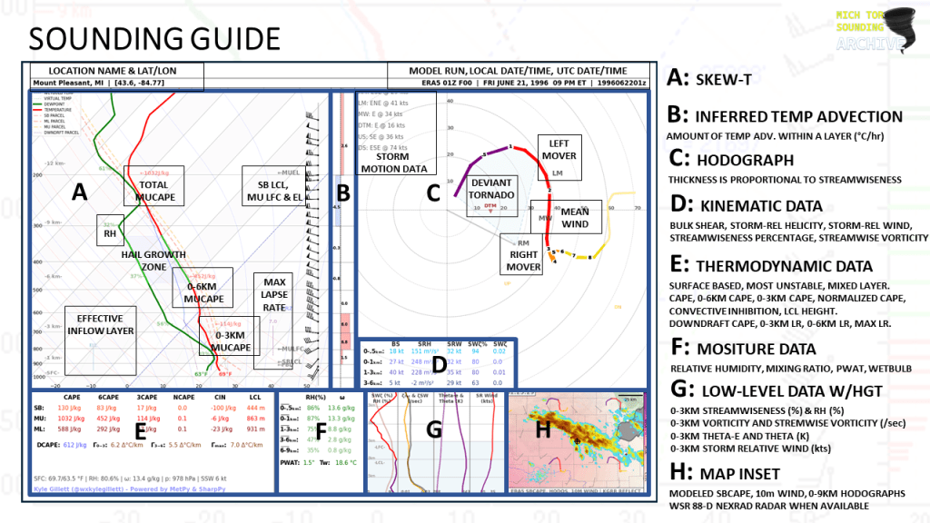
ABOUT THESE PLOTS:
This plot style has been developed in a way that acts to provide as much information to the user as possible with attributes designed specifically for the analysis of severe convective environments,and supercells in particular. You will also find that this particular plot style lacks many of the common and popular severe weather composite indices – that was intentional. Most, if not all, of the data provided on this plot, are considered ‘true’ observations of the atmosphere and are not related to the ideology of ‘composite-index-forecasting’ but may still be subject to heavy assumptions. The data on this plot are considered, by most, to be useful in determining critical characteristics of the atmosphere related to tornadogenesis. It should be noted that an analysis of the data presented is not provided here. This page is meant to act solely as a library of plots.

This page is currently not, and may never be entirely complete and is subject to changes at the discretion of the page author.
(C) CMU SCAMS & Kyle Gillett 2023, 2024
