Indiana Warm Front Perfection
A slow start to storm season in Michigan in 2017 gave us the feeling at 2017 just wasn’t the year for Michigan – whether that’s warm front supercells or even general storms, it wasn’t looking great.

Things were finally setting up for a local chase day on May 20, in Indiana. The day before the set-up looked okay with a strong nearly-negative shortwave trough crossing the central and northern plains bringing divergent southwest 500mb flow right into the southern Great Lakes. A stout 850mb jet was forecast to bring ample WAA and moisture northward while at the surface a warm front would be draped west-east across northern Indiana with the primary circulation of central Iowa. A secondary, mesoscale circulation was forecast to develop over central/northern IL-IN which could (would) aid in a focus for storm initiation. We decided to set our sights on that glorious warm front in northwest/west-central Indiana by 6-8PM EDT for a very minimal chance at magic.

After arriving in Indiana early in the afternoon, things were looking rather poor. We passed under an MCS during the afternoon as we crossed into Indiana. This worried us for destabilization potential and the latest HRRR runs showed storms at all different times and in different areas. By 4pm we made the choice to stick to our gut and original forecast in northwest Indiana. By 6PM storms were finally erupting in eastern IL, just west of our target area and we were in hot pursuit – the chase was on.

Initially, storms fired in a single north-south line were low-topped and very showery. By the time storms crossed into Indiana, our hopes for that warm front magic were fleeing as storms were simply messy and linear. But on approach, just as these storms came into view, a single cell began to emerge as a dominate supercell – with quite the structure for a young storm in this set-up. A wall cloud and a tail cloud were all present at one time. After filling up on gas it was time to get up close and personal with this little guy and see what’s up.

Here is how the chase evolved:

The poor thing went linear again for some time, with some cool structure at least. This cell did still exhibit some very weak and broad rotation.

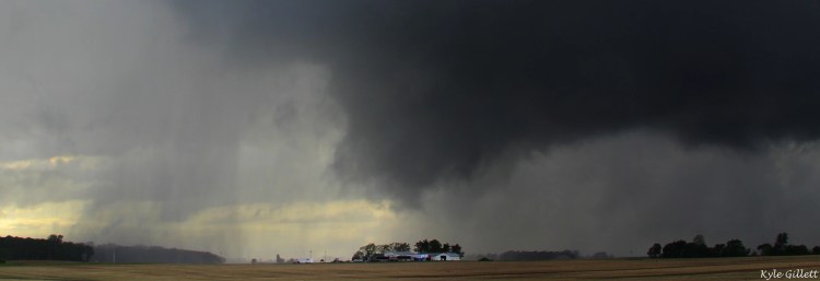
After some time, this storm moved into some very awesome chase terrain, beautiful wildflowers, wind farms, dark black Indiana dirt and good roads. By now the storm was showing signs of re-organizing itself with a new lowering of erratic scud beneath the northern flank of it’s base. A tail cloud developed as seen on the right.

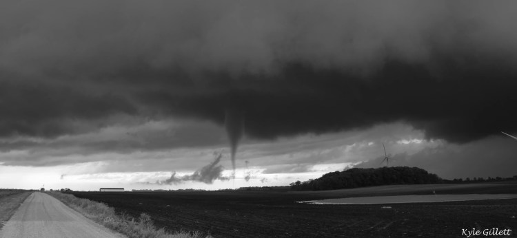
Ah, that’s better – now we have supercell structure. It sure is a cute little thing ain’t it. Had to go with the B/W here.
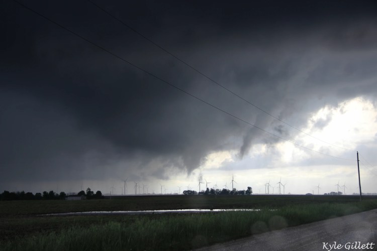
We allow ourselves to get closer to the business district of this storm just as things take the next step in ramping up. A large bowl lowering takes shape with two separate, scudy funnels. ITS TIME!

Ohhhhh baby, repositioning now as this large bowl lowering of the base continues with a more focused lowering in the center.

We’re not in Kansas anymore todo…. we are in Indiana??? The best wall cloud I have ever seen with an awesome example of RFD rain curtains on the back and left side of the wall cloud. A very low lowering dances in the middle.
ITS TORNADO TIME


Repositioning again while a funnel pokes out of the base.

Come on buddy, get down there.

AHAH, YES! – Also still in shock that this is INDIANA!


A little suction vortex here? Some slightly over-edited photos to show ground circulation and lofted debris.


The colors now?? And even this rope out is CRAZY!
This supercell would hang onto broad rotation for a bit longer with a new wall cloud but no more tornadoes like this. We would eventually drive through town and catch what was a likely brief rope tornado in the dark.
